Hurricane Center – Tropical Depression #4 Forms
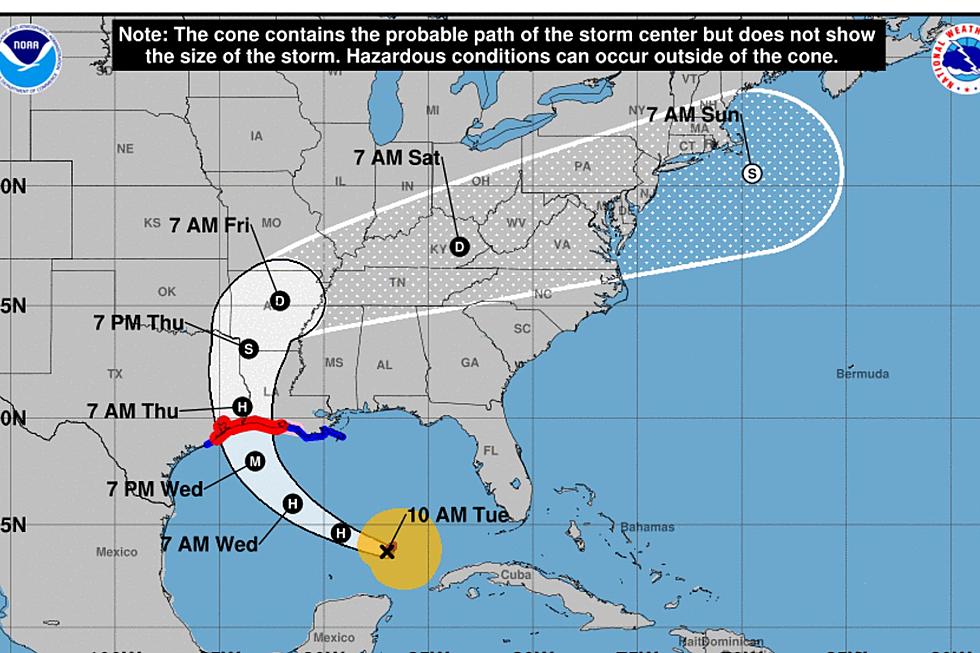
UPDATED: The National Hurricane Center has classified the area of disturbed weather in the Tropical Atlantic basin as a Tropical Depression. The system known as T.D. Four is expected to strengthen and be reclassified as Tropical Storm Danny by as early as this evening. Current forecast models suggest the system will continue to move in a west northwest motion for the next few days. The current intensity forecast has the system reaching Hurricane strength during the forecast period.
**Original Story**
Based on the latest satellite photos and analysis of upper data officials with the National Hurricane Center are predicting an area of disturbed weather moving across the southern Atlantic Ocean will become a tropical cyclone within the next 48 hours.
The probability according to forecasters 70% that this system will get better organized and strengthen. Should the system become strong enough to attain tropical storm status it would be given the name Danny.
The latest tracking models keep the system in the lower latitudes of the Atlantic basin for the next two days. After a 48 hour time frame there is some disagreement with the tracking models. Most of the more reliable models keep the system on a general west northwest track through the next five days. Depending upon strengthening and track there is a potential that this system could become a threat to the Windward or Leeward Islands.
Will this system be a player in the Gulf of Mexico? It is far too early to be thinking about the Gulf and any affect this weather maker could have on our immediate coastline. Among the factors this system will be facing are stronger upper level winds as the system approaches the Caribbean Sea and there is also some intrusion of Saharan dust that could impede the strengthening process. The best we can do is monitor the system for you and bring you updates as needed.
More From News Talk 96.5 KPEL