Tropical Update – The Latest Forecast Advisory For Acadiana
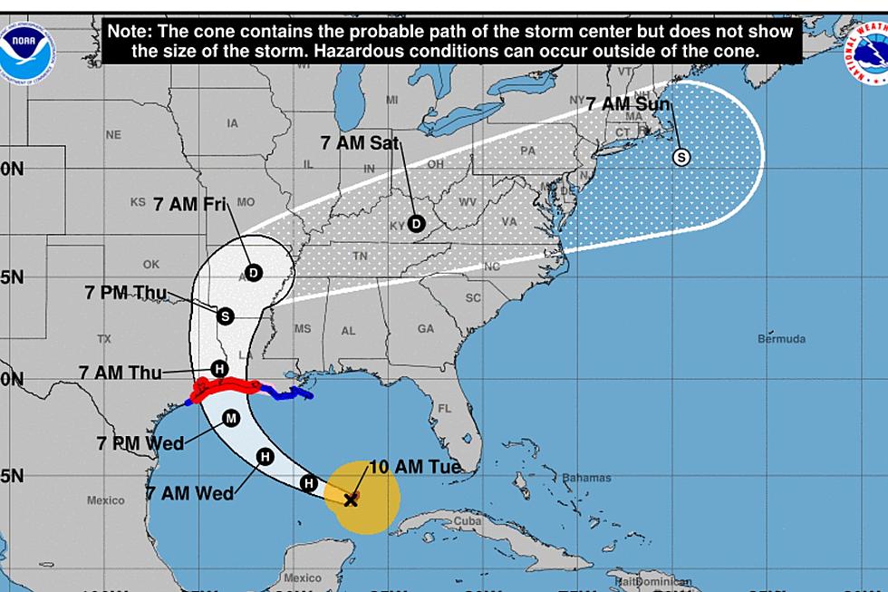
The National Hurricane Center continues to monitor a developing weather system in the northern Gulf of Mexico. The system is still being referred to as Potential Tropical Cyclone 2. That designation will likely change within a few hours. The system is expected to reach tropical depression status sometime today.
The latest advisory (4 AM CDT) has shifted the projected track of the system a little further to the east of the previous advisory. This new track still brings the center of the storm system onshore Saturday morning. If this forecast holds that would mean the center of circulation would pass between Lafayette and Baton Rouge but a little closer to Lafayette.
Forecasters still suggest that the storm system will strengthen into a Category 1 Hurricane or a very strong tropical storm by the time it makes landfall on Saturday. While there could be winds gusting to and above hurricane strength near the center of circulation, perhaps the biggest threat from this system will be flooding.
As you can see the precipitation forecast has also shifted further to the east when compared to previous advisories. Based on this latest information most locations in Acadiana could see anywhere from four to ten inches of rainfall between now and Sunday.
Forecasters also say that there is a threat of severe thunderstorms well ahead of the system and that threat will likely increase as it makes landfall. The Storm Prediction Center has placed much of South Central and Southeast Louisiana in the marginal risk zone for severe storms today.
The bottom line on this system is this. It is still developing and while tropical model guidance is becoming more consistent the track of this system remains uncertain. We suggest you continue to follow official information from reliable media sources.
For the latest alerts and bulletins concerning this developing weather situation, we encourage you to download our Mobile App for your smartphone. Be sure and open the settings tab and select alerts for Breaking News and Weather.
More From News Talk 96.5 KPEL