Hurricane Ida Now Expected to Be Category 4 at Landfall
The bad news for Acadiana and the rest of the Louisiana gulf coast just got worse.
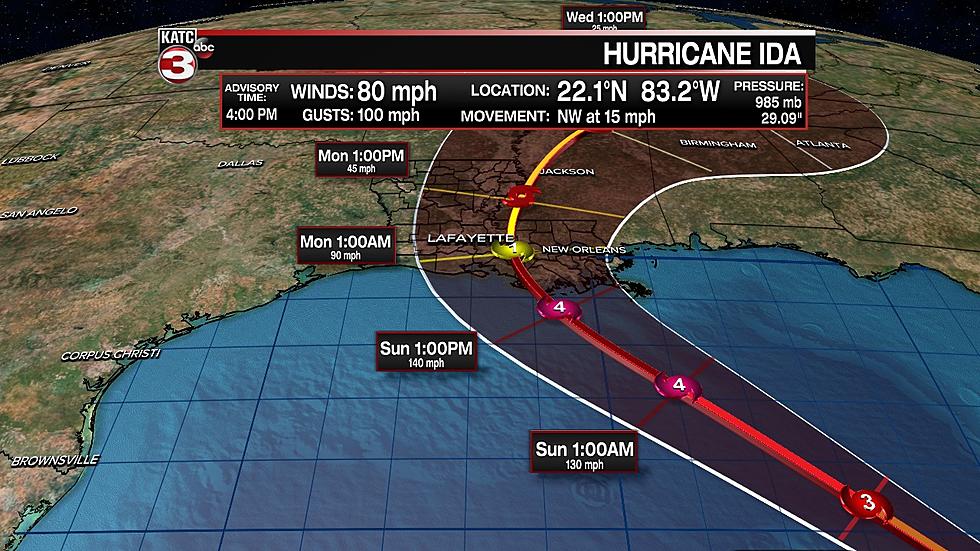
Hurricane Ida is now expected to have Category 4-strength winds by the time it makes landfall on Sunday. That's according to the National Hurricane Center's 4 p.m. advisory. KATC chief meteorologist Rob Perillo says those winds could approach the 140 mile-per-hour mark.
A hurricane warning is now in effect for all of Acadiana. Acadiana's coastal parishes are also under a storm surge warning.
The NHC's meteorologists say in their forecast discussion:
Once Ida moves past western Cuba and into the southeastern Gulf of Mexico, it will be moving through a very favorable oceanic and atmospheric environment consisting of high ocean heat content waters, low vertical wind shear, and a moist low- to mid-level atmosphere. These conditions are likely to result in a period of rapid strengthening during the next 24 to 36 hours. In fact, with the higher initial wind speed, the intensity guidance has significantly increased this cycle, and the bulk of the guidance now brings Ida to category 4 intensity.
That rapid intensification is expected to happen in the next 24 to 36 hours.
The National Hurricane Center expect Ida to bring life-threatening winds and storm damage to coastal Louisiana. The NHC forecast discussion says:
There is a danger of life-threatening storm surge inundation Sunday along the coasts of Louisiana and Mississippi within the Storm Surge Warning area. Extremely life-threatening inundation of 10 to 15 feet above ground level is possible within the area from Morgan City, Louisiana, to the Mouth of the Mississippi River. Interests throughout the warning area should follow any advice given by local officials.
The discussion also says all of coastal Louisiana, including Greater New Orleans, should brace for "catastrophic winds." Coastal Louisiana could also see flash floods from heavy rains, with some areas receiving up to 20 inches of precipitation.
Ida remains on a general northwestward track, with landfall still expected to happen near the St. Mary/Terrebonne Parish line sometime Sunday. The current forecast model predicts landfall to happen late Sunday afternoon or early Sunday evening, with the storm rapidly losing strength after landfall.

A hurricane warning is in effect for all of Acadiana. Acadiana's coastal parishes are also under a storm surge warning.
Right now, Ida's eye is located at latitude 22.1 North, longitude 83.2 West and moving northwest at 15 miles per hour. That location is about 45 miles northwest of Cuba's Isle of Youth and about 90 miles southwest of Havana. Ida has sustained maximum winds of 80 miles per hour and a minimum central pressure of 985 millibars.
Stay tuned to this station for more updates.
20 Items You Need to Have in Your ‘Hurricane Box’ This Year
Six Things A Cajun Needs To Survive A Storm
Hurricane Game Plan, How We Get Ready at My House
Aerial Pictures of Southwest Louisiana Before & After Hurricane Laura
Things You Want or Need After Surviving A Hurricane
Prevent Hurricane Anxiety By Prepping Now
More From News Talk 96.5 KPEL