Severe Weather Threat Likely in Louisiana Sunday
The past several days have been off the charts as far as gorgeous weather is concerned. While we are all social distancing and doing our part to quell the coronavirus threat many of us have used the great weather to catch up on gardening, lawn maintenance, and just walking around the neighborhood.
It looks as if we'll have today and maybe Saturday for those kinds of activities but Sunday might be a good Stay-at-Home and inside kind of day. That's because Mother Nature appears to be poised to "send us the bill" for all that nice weather in the form of a significant severe weather threat.
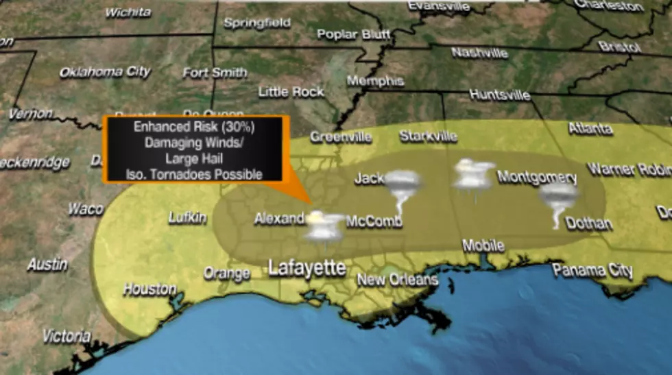
The Storm Prediction Center guidance suggests that a disturbance will approach Louisiana from the west during the day on Saturday. This should kick off a marginal threat for severe weather over the northern and western parts of the state.
By Sunday the disturbance will bring a more significant threat for strong storms with hail and high wind to much of Louisiana. Right now it appears as if I-10 will be the southern border of the enhanced severe storm threat but bad weather is like horseshoes, close counts.
The best threat of strong storms in the area will come during the middle of the day and into the afternoon and early evening hours of Sunday. There could be watches and warnings posted for tornadoes and severe thunderstorms.
Our suggestion to you is to visit the settings on our mobile app and make sure you have Weather Alerts selected. That way you'll get the latest updated information on storms as they move through the area.
Weird Louisiana Laws
More From News Talk 96.5 KPEL