

Louisiana Now Under Tropical Storm Watch as Gulf Depression Stalls
LAFAYETTE, La. — The National Hurricane Center’s 4 p.m. advisory Monday shows Tropical Depression Two has moved only marginally since it formed Sunday, and Louisiana is now inside the storm’s watch area for the first time.
As of 4 p.m. CDT, the depression was centered about 105 miles south of Panama City, Florida, with maximum sustained winds of 35 mph and a minimum central pressure of 1005 millibars. It was creeping northwest at just 3 mph.

Louisiana Now Under Storm Watches
A Storm Surge Watch is in effect from the Alabama and Florida border to the mouth of the Mississippi River. A Tropical Storm Watch now runs from the Ochlockonee River in Florida all the way west to the Jefferson and Plaquemines Parish border in Louisiana. Both of those watch areas moved into southeast Louisiana with this advisory.
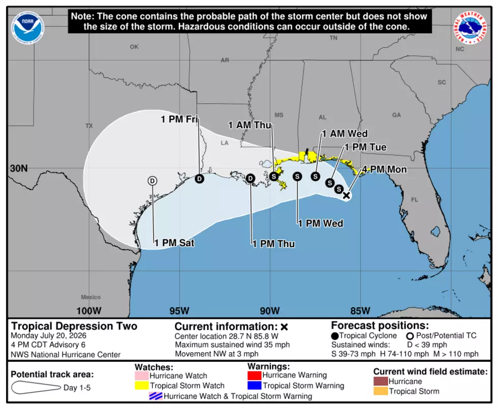
The Hurricane Center’s storm surge outlook lists possible inundation of 1 to 3 feet above ground for Morgan City to the mouth of the Mississippi River and for Lake Pontchartrain, if the peak surge lines up with high tide. The stretch from the mouth of the Mississippi River to the Alabama and Florida border could see 2 to 4 feet. Forecasters said additional watches may still be needed tonight or Tuesday for areas of Louisiana and Texas outside the current watch zone.
Why the System Keeps Stalling
The depression’s slow movement has been the defining feature of this storm since it formed Sunday. Forecasters described the system as drifting erratically for most of Monday, and satellite tracking shows it has covered barely 100 miles in the 24 hours since Sunday afternoon. The Hurricane Center said the depression is caught in light steering currents between two mid-level ridges, one over the central U.S. and one near the Bahamas, and neither is strong enough yet to push the system in a consistent direction.
Forecasters expect the U.S. ridge to gradually take over as the dominant steering influence, nudging the depression northwest and then west over the next day and a half. The Hurricane Center noted uncertainty in exactly how close the center tracks to the northern Gulf coast and how sharp that westward turn ends up being, since strong wind shear could keep the storm’s center displaced south of the official forecast track.
Track and Strength Going Forward
The depression is forecast to reach tropical storm strength within about 12 hours, early Tuesday. If it does, the system would be named Bertha, the next name on this year’s Atlantic storm list. The Hurricane Center’s forecast calls for the system to peak at 50 mph late Tuesday into early Wednesday as it approaches the northern Gulf coast, then move inland along the Louisiana and Mississippi state line late Wednesday night into Thursday, tracking across south-central Louisiana as it weakens.
Forecasters expect the system to drop to a remnant low within five days, with wind shear and land interaction potentially causing it to dissipate entirely somewhere between three and five days out.
Rainfall and Flooding Threat
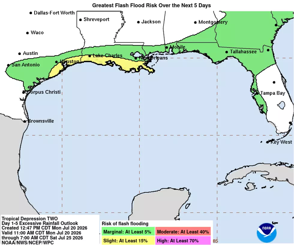
The Hurricane Center’s rainfall outlook now extends through Friday, calling for 2 to 4 inches with isolated totals near 8 inches along the Gulf Coast and nearby inland areas from western Florida to the middle Texas coast, including southern Alabama, Mississippi and Louisiana. That rain is expected to raise the risk of flash flooding, especially in cities and towns where drainage systems fill up fast. An isolated tornado or two is also possible over the Florida Big Bend region Monday evening.
What Happens Next
Air Force Reserve and NOAA aircraft are scheduled to fly into the depression again Monday evening to gather fresh data on its strength and structure. The Hurricane Center’s next intermediate advisory is set for 7 p.m. CDT, with the next complete advisory at 10 p.m. CDT. KPEL News will continue tracking any changes to the watches affecting Acadiana and southeast Louisiana.
You May Also Like...
- Tropical System In the Gulf, What Louisiana Should Watch
- Louisiana Is in the Bullseye Again. Here's What Every 2026 Hurricane Forecast Says About the Gulf Coast.
- CSU 2026 Hurricane Forecast: Below Average but Gulf at Risk
Most Feared Weather Events in Louisiana
Gallery Credit: Joe Cunningham