

2026 Hurricane Season Forecast Puts Louisiana’s Gulf Coast in the Crosshairs Again
LAFAYETTE, La. (KPEL News) — The 2026 Atlantic hurricane season officially begins on June 1, and the earliest forecasts carry a warning that doesn’t show up in the storm count alone. Overall numbers may land near or below the historical average, but the Gulf of Mexico is loaded with warm water, and forecasters are already pointing to the northern Gulf Coast as one of the most at-risk areas in the country.
Three forecasting groups have already weighed in. A fourth, Colorado State University, will release its closely watched initial prediction on April 9. NOAA typically follows in late May. The National Hurricane Center starts issuing regular Tropical Weather Outlooks on May 15.

What Forecasters Are Predicting for 2026
Tropical Storm Risk (TSR) got the ball rolling in December 2025. The London-based forecasting group projected a near-normal season with 14 named storms, 7 hurricanes, and 3 major hurricanes, with an Accumulated Cyclone Energy (ACE) index of 125, right at the 30-year average. TSR noted that forecast confidence was historically low at that lead time, mostly because of uncertainty around whether El Niño would develop during the summer months.
Climate Impact Company followed with its own December outlook, calling for 12 to 16 tropical storms, about 6 hurricanes, and 3 to 4 intense hurricanes, with an ACE range of 105 to 140. Their projections lean on analog years of 2004, 2009, 2015, and 2023, all seasons where El Niño coincided with warm Atlantic waters.
AccuWeather put out the most detailed outlook on March 25, 2026, projecting 11 to 16 named storms, 4 to 7 hurricanes, and 2 to 4 major hurricanes (Category 3 or higher). The company also expects 3 to 5 direct impacts on the United States throughout the season.

For context, the 30-year average (1991–2020) is 14 named storms, 7 hurricanes, and 3 major hurricanes.
Colorado State University’s forecast drops April 9. CSU has been issuing seasonal hurricane predictions since 1984, and its outlooks are among the most closely tracked in the field. The team typically publishes updates in June, July, and August as conditions sharpen.
El Niño vs. Warm Water: Two Forces Working Against Each Other
Two climate forces are pulling in opposite directions this year, and which one wins out will determine whether 2026 stays quiet or turns dangerous.
El Niño is expected to build through the summer and fall. It warms waters in the eastern Pacific Ocean and typically ramps up wind shear across the Atlantic basin. Wind shear tears apart developing storms and can keep them from ever organizing into hurricanes. Since the satellite era began in the 1960s, El Niño years have averaged about 10 named storms and 5 hurricanes, well below the La Niña average of roughly 15 named storms and 8 hurricanes.
AccuWeather puts the odds of a “Super El Niño” at about 15 percent. If that develops during the second half of the season, it could shut down storm activity in October and November almost entirely.
On the other side of the equation: Atlantic and Gulf of Mexico sea surface temperatures are already running well above normal, and that warmth extends hundreds of feet below the surface. That gives hurricanes a deep reservoir of energy to feed on. AccuWeather Lead Hurricane Expert Alex DaSilva warned specifically about rapid intensification, where a storm balloons in strength just before making landfall. That concern is not theoretical. In 2018, Hurricane Michael went from a tropical depression on October 7 to a Category 5 landfall at Mexico Beach, Florida, on October 10, reaching 160 mph at the coast. Much of that intensification happened in the final 24 hours.
The last time El Niño showed up during hurricane season was 2023. The Atlantic was record-warm that year, and El Niño’s wind shear couldn’t overcome it. The result was 20 named storms. Ocean temperatures in 2026 are expected to run warm again, though not at 2023 levels.
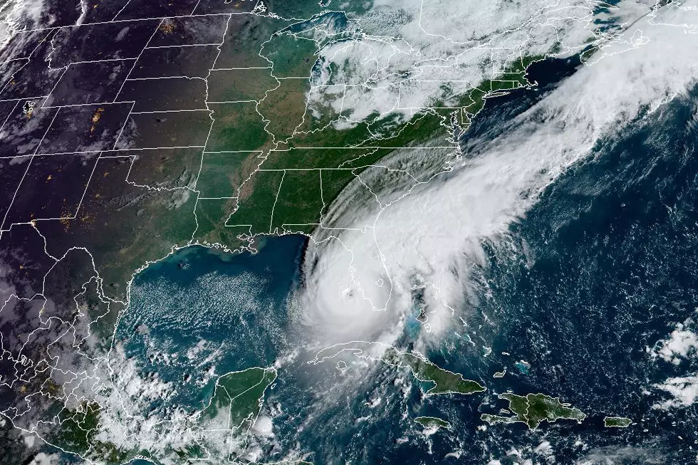
Why Louisiana and the Northern Gulf Coast Are in the Crosshairs
AccuWeather’s landfall risk analysis zeroes in on the northern and northeastern Gulf Coast as the area most likely to take direct tropical impacts in 2026. That zone stretches from just west of New Orleans through coastal Mississippi, Alabama, and into the Florida Panhandle.
The projection comes from AccuWeather’s review of 14 past seasons with atmospheric setups similar to what 2026 should look like. In analog years like 2009, 2014, 2018, and 2023, storms brought more impacts to the northern Gulf than to other parts of the Gulf and Atlantic coastlines.
Texas faces lower risk under this pattern, but no part of the Gulf is ever truly safe. In 2023, Tropical Storm Harold was one of the only U.S. landfalls, and it hit southern Texas.
AccuWeather’s analysis of storm clustering in similar analog years found a concentration of activity from just west of New Orleans all the way down to Tampa along the northern and eastern Gulf.
Louisiana’s risk doesn’t hinge on storm counts. Low-lying terrain, miles of exposed coastline, a shallow continental shelf that amplifies storm surge, and dense energy infrastructure along the coast all make the state uniquely vulnerable. One well-placed storm can define an entire season here, no matter how quiet the rest of the Atlantic basin turns out to be.
“Homegrown” Storms Could Mean Less Warning Time
There is a separate concern about storms that skip the traditional path entirely. Most Atlantic hurricanes form off the coast of Africa and take days to cross the open ocean before threatening land. “Homegrown” storms are different. They develop right in the Gulf of Mexico, the western Caribbean, or the western Atlantic when a stalled front or disturbance sits on warm water long enough to organize. Because they form so close to land, they leave far less time to prepare.
AccuWeather sees homegrown development as a real threat before and just after the official June 1 start date. Gulf and western Caribbean waters are warm enough right now that it won’t take much to spin up tropical activity early.
The Bermuda High matters here too. DaSilva expects it to sit farther south and east again this year, similar to 2025. That can steer some Atlantic storms away from the U.S. coast, but it does nothing to stop Gulf-developing systems that never interact with those steering patterns in the first place.
What the 2025 Season Tells Us About 2026
The 2025 Atlantic hurricane season ended with 13 named storms, 5 hurricanes, and 4 major hurricanes. On paper, that looks close to average. It wasn’t. Three of those hurricanes reached Category 5 intensity, just one short of the all-time record of four set in 2005. Erin, Humberto, and Melissa all maxed out at the top of the scale.
The continental U.S. dodged every hurricane in 2025. Tropical Storm Chantal was the only U.S. landfall, with about $500 million in damage. Jamaica was not as fortunate. Hurricane Melissa hit the island as a Category 5 and left an estimated $6 to $7 billion in destruction. The World Meteorological Organization retired the name Melissa in March 2026.
The season went almost completely silent between August 24 and September 16. No named storms formed during that stretch, something that hadn’t happened since 1992. Then activity exploded. The period after September 16 produced the fifth-most ACE on record.
The lesson for 2026 is straightforward: the number of storms on the season summary doesn’t matter if one of them parks over your parish. A below-average year can still be catastrophic.
NHC Rolls Out Redesigned Forecast Cone for 2026
The National Hurricane Center is making a major change to the forecast cone graphic, and it matters for anyone who lives inland. The updated cone will display tropical storm and hurricane watches and warnings for inland areas for the first time, not just coastal zones. The change follows a successful test run during the 2025 season.

The NHC is also testing a new experimental cone that uses ellipses instead of circles at each forecast point. The ellipses reflect uncertainty in both speed and direction, and they capture 90 percent of possible track outcomes instead of the traditional 67 percent. The cone itself will be about 4 to 8 percent smaller than last year’s version, thanks to improvements in forecast accuracy.
A mobile-friendly version of the NHC website should go live around June 1 at nhc.noaa.gov/mobile.
What Louisiana Families Should Do Now
Hurricane season is two months out. That’s still enough time to handle the things that become impossible once a storm shows up in the Gulf.
Check your insurance now. Review wind and flood policies. NFIP flood policies carry a 30-day waiting period before coverage kicks in. If you wait until June, you’re already behind.
Build your supply kit early. Water, batteries, non-perishable food, medications, important documents, and cash. Shelves empty out fast once a storm enters the Gulf. Get ahead of it now.
Know your evacuation zone and route. Lafayette, Vermilion, Cameron, Iberia, and St. Martin parishes all have specific evacuation plans. GOHSEP keeps updated routes and shelter information on its website.
Pay attention to the new forecast tools. The NHC’s updated cone will show inland warnings this year. Wind and rain from a Gulf storm can push deep into Acadiana and central Louisiana, even if you’re nowhere near the coast.
You May Also Like...
- From Katrina to Laura: The Hurricanes That Shaped Louisiana
- This Hurricane Season Change Could Save Louisiana Lives
- Louisiana Prepares: 15 Essential Items Every Hurricane Kit Needs
20 Items You Need to Have in Your ‘Hurricane Box’
Gallery Credit: TSM Lafayette
More From News Talk 96.5 KPEL


